DFID Research: A responsive database in agricultural research
The CGIAR Aquatic Agricultural Systems (AAS) programme is planning to launch a new GIS database, providing detailed geographical information on worldwide food production systems.
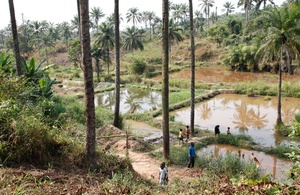
Picture: Russell Watkins/ DFID.
The CGIAR Aquatic Agricultural Systems (AAS) programme is planning to launch a new GIS database, providing detailed geographical information on worldwide food production systems.
AAS is led by the World Fish centre. With more than 700 million people dependent on Aquatic agricultural systems, living in coastal areas or in flood plains, AAS recognises the unique and diverse challenges faced by these communities. With rising sea levels and increasingly extreme weather patterns, people working in aquatic agriculture are often more vulnerable to climate change and reduced food security.
AAS conducts participatory action research within these communities in order to reduce this vulnerability. Studying the integrated farming strategies of existing communities in these areas, the programme aims to reduce poverty, marginalisation and climate change sensitivity by maximising the productivity of these methods and developing new adaptive, sustainable agricultural strategies.
The programme’s work is carried out within six major themes:
- Sustainable increases in system productivity
- Equitable access to markets
- Social-ecological resilience and adaptive capacity
- Gender equality
- Policies and institutions to empower AAS users
- Knowledge sharing, learning, and innovation
It is as part of the Knowledge sharing, learning and innovation thematic that this new database is being generated.
Alongside the World Fish Centre and the CGIAR programme on Climate Change, Agriculture and Food Security (CCAFS), AAS is working on developing a database designed specifically around user needs. Using a ‘bottom up’ approach, the database will be built via a helpdesk which will feed user requests into the framework of its content.
Ensuring the database is populated with outputs generated from user requests, all maps and visualised data will be Open Source and reproducible. This will allow data to be used in multiple ways and will accelerate the use of shared information by researchers.
The online portal will store up-to-date ecological and socio-economic data, with spatial information and data on river systems, climate, distributions of fisheries, poverty levels, food security, and nutrition. The database will provide information on key regions including Bangladesh, Philippines, Solomon Islands, Cambodia and Zambia.
This platform will support AAS in its drive to use knowledge sharing as a means of building participatory action research. Designing the database around the demands of the researchers means that data can be tailored for specific users; visualisation of relevant factors can then be fed back into the communities on the ground who in turn can feed their responses back to the helpdesk.
To contact the helpdesk to request further information or specific data sets, maps or for help with spatial modelling email the team at gis-helpdesk@worldfishcenter.org.
The Consultative Group on International Agricultural Research (CGIAR) is funded by DFID and coordinates research into international agricultural research through 15 centres and numerous challenge programmes. Working to reduce rural poverty, increase food security, improve human health and nutrition, and ensure more sustainable management of natural resources, CGIAR collaborates with hundreds of partner organizations, including national and regional research institutes, civil society organizations, academia, and the private sector.